
See your property's potential before investing in detailed plans.
You're planning a build or an extension and don't yet know how the land actually sits.
What you get
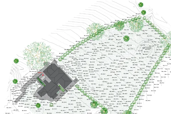
A preliminary contour map and site-plan concept from public elevation data — enough to plan, price and brief a professional.
Most people planning a build start by ringing an architect — and pay professional hourly rates to answer a question they could have answered first: what does the land actually do?
We take free government elevation data over your address and turn it into a contour map and a site plan concept: where the ground is level, which way water runs, and how a building of roughly your size could sit on the plot.
A fraction of the cost of a survey, no site visit, and something concrete to put in front of an architect, a builder or a lender.
Where our work stops
A concept to think and plan with. It isn't a certified survey and won't satisfy a permit office.
Your permit office will want a licensed survey and drawings from an architect or engineer. This is what you use to work out what you want before you start paying for those.
What you get
Enough to plan with, price against, and brief a professional from.
A contour map of your plot
Lines showing where the ground rises and falls, at an interval you can actually read. This is the drawing an architect asks for first.
Where the level ground is
The parts of your plot flat enough to build on without moving significant amounts of earth — and what it would take to level the parts that are not.
A site plan concept
A sketch layout showing how a building of roughly your size could sit on the plot, oriented to the slope and the access.
Which way water runs
Where rain drains across the site and where it collects, so the extension does not end up in the wet corner.
Rough earthworks idea
A sense of how much cut and fill a given position would need — the number that quietly decides your groundworks budget.
Files your architect can use
PDF for you, and CAD files for whoever you hand it to next, so nobody starts from scratch.
Where this works
This depends on free public survey data — so it only works in some countries.
These governments have flown their whole territory with survey aircraft and published the results free. That data is why there is no site visit and no surveyor's day rate.
Coverage varies within countries as well as between them. Not on the list? Tell us where the land is and we will check what exists over your plot — free, and it takes minutes.
How accurate it is
Vertical accuracy is typically 10–30 cm depending on the source dataset and how much canopy sits over the site. That is good enough to plan around and nowhere near survey grade — which is the honest trade for work that needs no site visit.
| Country | Data source | Coverage |
|---|---|---|
| United States | USGS 3DEP | Near-national coverage |
| England | Environment Agency | National LiDAR Programme |
| Netherlands | AHN | National, high density |
| Denmark | Danmarks Højdemodel | National |
| Finland | NLS Finland | National |
| Canada | HRDEM / provincial | Partial — populated corridors |
| New Zealand | LINZ | Most regions |
| Australia | ELVIS / Geoscience Australia | Partial — varies by state |
Coverage is checked against your specific location before you pay anything.
Where this sits
The step before the expensive steps.
The usual order — decide, pay an architect to draw it, pay a surveyor to measure, then find the two do not fit. Reversing the first two steps costs less.
- You are here
Preliminary site plan
What the land does, and roughly what fits on it. Days, not weeks. No site visit.
- Next
Licensed survey
A surveyor measures your boundaries and levels on the ground. Needed before anything gets built or submitted.
- Then
Architect and permit drawings
The design itself, and the drawings your permit office will accept — produced by people licensed where you are.
First step
Send your address or plot boundary.
We reply within 24 hours and send a full written scope within two business days.
Just the address will do
Or your plot boundary marked on a map, plus a title or deed plan if you have one. A sentence on what you hope to build points the concept somewhere useful.
We will confirm the elevation data exists over your address before you pay anything. If it does not, we will say so.
Before you ask
What property owners ask first
Will the council accept this for planning permission?
No. This is a planning tool for you, not a permit document. A permit office wants a survey by a licensed surveyor in your jurisdiction and drawings from an architect or engineer. This lets you work out what you want before you start paying either by the hour.
Then what is the point of it?
It stops you commissioning detailed plans for something the land will not take. People spend thousands on drawings, then find the slope means the garage cannot go where they assumed. Finding that out first is much cheaper.
How accurate is it?
Within 10 to 30 centimetres, depending on source data and tree cover. Fine for deciding where a building goes and what levelling it needs. Not enough to set foundation or finished floor levels — your builder will need a real survey.
What do you need from me?
Your address, or the plot boundary marked on a map. If you have a title plan or a deed plan, send that too. A sentence about what you are hoping to build helps us point the concept in the right direction.
Do you design the building?
No. We show what the land does and sketch how a building of roughly your size could sit on it. Designing it is an architect’s job — this is the document that makes their first meeting much shorter.
My property is not in one of the listed countries.
Tell us where it is before paying for anything. Coverage varies within countries as well as between them, and we will check what exists over your specific address and tell you honestly. That check costs nothing.
Also produced here
See your land.
Send your address or plot boundary.
Reply within 24 hours. Written scope within two business days.