
Fly more, process less — deliver professional maps without the processing headache.
Capturing great aerial data is easy. Turning it into professional deliverables takes time you'd rather spend flying.
What you get
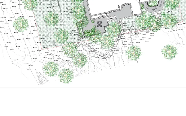
Ground classification, vegetation filtering, surfaces, contours and CAD-ready output in your client's coordinate system — including canopy-heavy sites automated platforms can't resolve.
You already have the hard part. The flight is planned, the control is in, the data is clean. Between that and an invoice sits a week of classification work.
We take the raw cloud or imagery and return what the client asked for: a ground surface that holds up, contours that look drawn rather than traced off a raster, and files that open in the coordinate system their engineer works in.
- Ground classification and vegetation filtering on LiDAR and photogrammetric clouds
- DTM and DSM extraction, with breaklines where the terrain needs them
- Contours at your interval, smoothed to survey convention rather than raw raster output
- Orthomosaic and DEM production from raw imagery
- Volume calculations — stockpiles, cut and fill, with method stated
- CAD-ready deliverables in your client’s coordinate system and vertical datum
What to send
Plus the CRS and vertical datum your client needs. If you do not know it yet, send the data anyway — that question is easier to answer with the file in front of us.
What comes back
Where our work stops
You own the flight, the client and the deliverable. We're invisible in the chain.
No logo on the deliverable, no contact with your client, no mention of us anywhere in the chain. That is the arrangement we want too.
Where automated platforms stop
Canopy-heavy sites, where the software gives up.
Propeller, DroneDeploy and Pix4D are good software. On an open site with clean ground returns they beat any human on speed and price — if that is your work, you do not need us.
Dense canopy is a different problem. Few pulses reach the ground, and those that do arrive mixed with returns off undergrowth and deadfall. An automated classifier applies one assumption to the whole site, so it either leaves vegetation in your surface as phantom terrain or strips out real ground with the scrub. Both look plausible until an engineer sets a grade against it.
The fix is not a better algorithm. It is classifying in zones, cutting profiles through the result, and re-doing what is wrong — hours of judgment a platform priced per hectare cannot offer.
The trial job
Send one dataset. See the output before you route client work through us.
We reply within 24 hours and send a full written scope within two business days.
Send the awkward one
A clean open-field dataset proves nothing — the software would have handled it. Send the site with tree cover, or the one where the automated surface came back wrong.
One dataset, processed and returned, before any client work goes near us. If the output does not hold up, you have lost a file transfer and nothing else.
Client reviews
Operators and firms who sent a dataset first
Every quote below is a verbatim review left by a paying client on a public profile, with the handle and country kept so it stays checkable. Nothing here is written by us.
“Great work completed, everything done as requested even with a couple of revisions. Couldn't ask for more.”fns_surveying
United Kingdom · Topographic mapping from point cloud data
“Great guy, very responsive, good communicator. Will certainly collaborate with him again.”jordansloan494
United States · Repeat client · Contour and site plans
Before you ask
What operators ask before routing a job through us
Do you fly?
No, deliberately. No aircraft, no operating certificate, no interest in your client. You fly and own the relationship; we sit behind you producing the deliverable. Routing work through us does not introduce a competitor to your own client.
What is different about a canopy-heavy site?
Few pulses reach the ground, and those that do are mixed with returns off undergrowth and deadfall. An automated classifier picks one global assumption and either keeps vegetation in the surface or strips out real terrain. The fix is manual: classify per zone, inspect profiles, re-cut what is wrong. Slow, and why software platforms structurally cannot do it.
Which coordinate system will the output be in?
Whichever your client works in. Tell us the horizontal CRS and vertical datum, including the geoid model if it matters. Unsure what they need? Send what you have and we work it out before processing, not after.
How large a dataset can you take?
Send a transfer link rather than trying to attach anything. Multi-tile LAS/LAZ surveys are normal. If the dataset is large enough that transfer is itself a problem, say so in the first email and we will sort out a route that works.
What if the software already gave me a surface?
Send it along with the raw cloud. Seeing what the automated output produced tells us quickly whether the problem is classification, a datum mismatch, or something in the flight itself — and occasionally it tells us the existing surface is fine and you do not need us for that job.
Work of this kind
Also produced here
Upload a test dataset.
Send one dataset. See the output before you route client work through us.
Reply within 24 hours. Written scope within two business days.